Event
An event is the central unit in Protegear Sports. It sets when and where a sporting event is to take place.
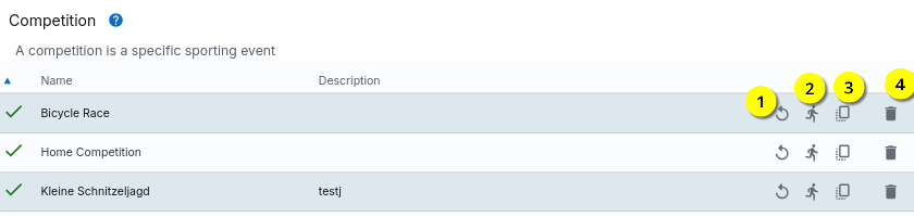
With an event is deleted, with creates a copy of an existing one.
The time measurement can be started with and enables a replay of an event using data from a data source (no live data).
A new event can be created with ; clicking on an existing event opens a detailed view.
Edit event
The basic data of an event is entered directly at the beginning of the entered:
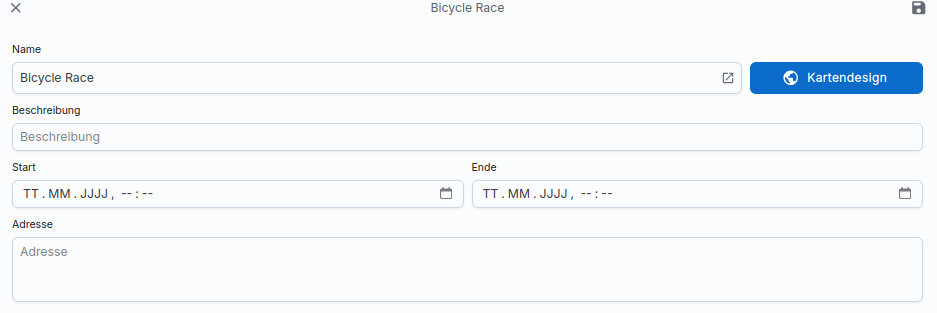
The time stamps for the start and end of the competition are freely selectable, should must be set (roughly) correctly. Because only within this period will the System can access live data from devices at all. If the competition has not yet started or has finished, the data sent by the devices are Data is not taken into account. It is therefore important that the timestamps contain at least the correct days. The times can be changed at this point can still be set too roughly. This is because the exact start or End date only known at short notice.
The data for name, description and address can be changed as required.
Rating
In the end, an event consists of analysing the data sent by the devices and then regularly reduce these to a valuation.
The evaluation is described separately, but at this point a rating must be selected for an event. This evaluation function is then called by the system at runtime and returns a Data record, which can then be displayed in the ranking.
Ranking
The customising of the presentation for the event and the ranking can be with the help of CSS. By default, some CSS classes and styles are already which you can adjust at any time. Please note that You should only use CSS classes and CSS IDs that have unique names; generated CSS styles can change at any time and can therefore lead to unexpected Behaviour.
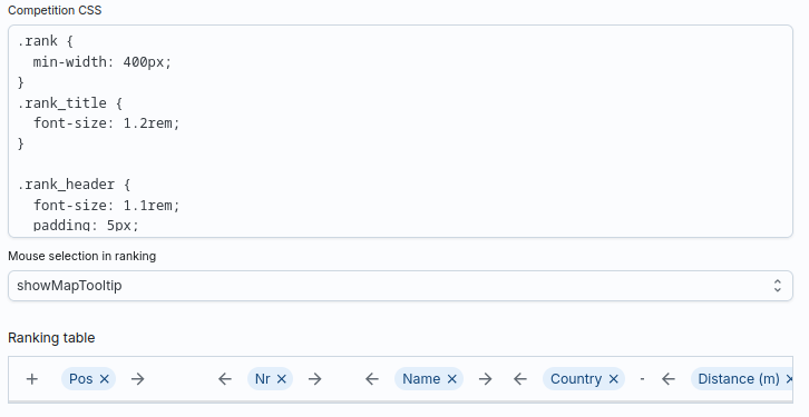
For example, to organise the first three places in the ranking differently, you can use the following Use code:
1 2 3 4 5 | |
The action for Mouse selection defines what happens if in the ranking is clicked on a participant. By default, the participant is displayed in of the map is marked by a tooltip. However, you can also change this behaviour switch off.
Finally, you define the columns for the ranking table. Each column has a title and a data value. This value can be selected from a list of predefined values; however, you can also select a value from the data set of the valuation function and thus use your own columns with calculated Create values.
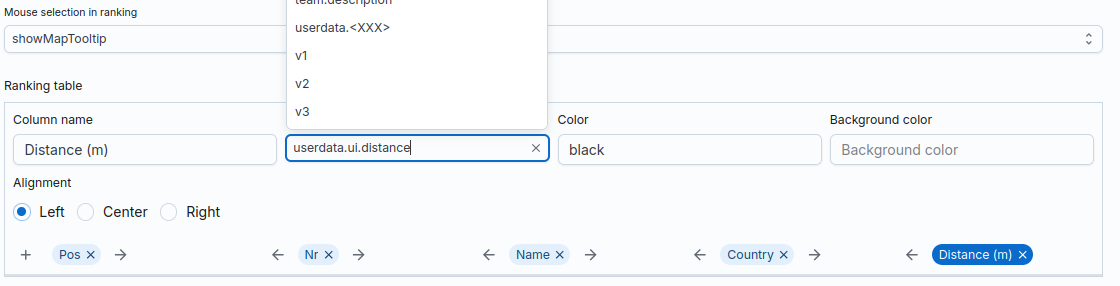
In the example, the userdata.ui.distance field is accessed here. This
Field is not part of the sports platform, instead the structure is
userdata of the evaluation function in order to enter data there yourself
to be stored. This means that the field ui.distance is excluded from the evaluation function
must be created!
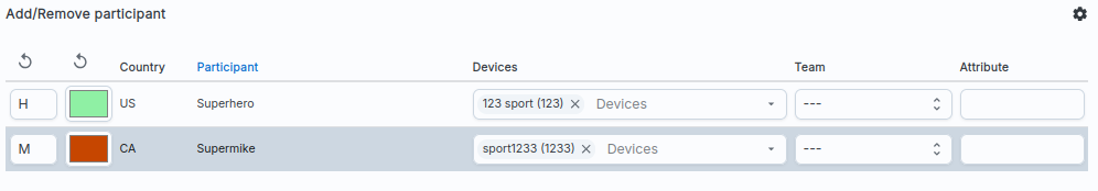
Map
All participants are displayed on the map at runtime. You can use the central marker to define the position to which the map is to be moved when the Page is centred by a user.
You can also add layers, which can have different types:
- Marker: A marker is a dot on the map.
- Course: A line consisting of several points.
- Region: One area
Each layer has a type and can contain several elements. A layer can therefore contain of type Marker contain many markers; a course layer can contain many lines and several areas can be created in one region.
Marker
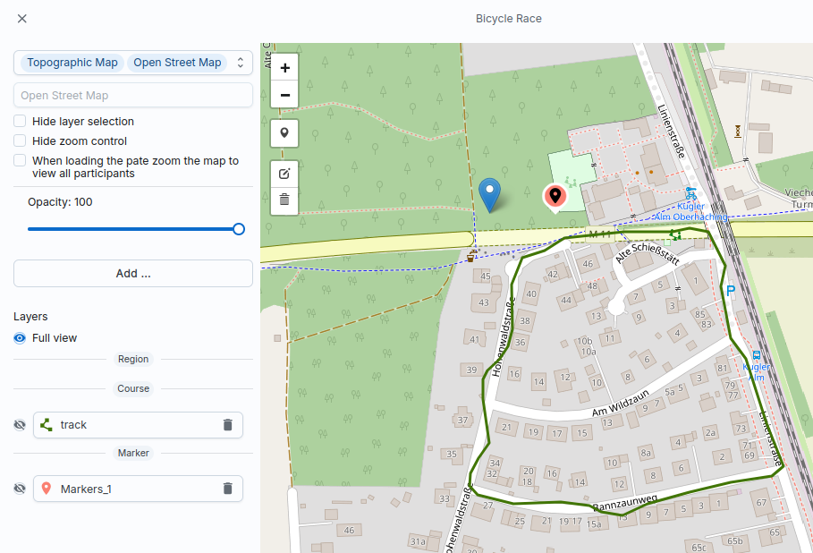
Markers can contain a text for the marker and for a pop-up to be displayed.
The system displays the internal, unique name of the marker (Markers_1_0); this
Name is made up of the name of the layer and the index of the marker within the layer
together. You can use this name in the Reducer code to access it. This
Name can also be used in the CSS rules as a CSS ID to identify the specific element
to select.
Maintain the text for a pop-up in the text field,
which is displayed when the marker is clicked. In
you can specify a text for the marker. If this text begins with a prefix
fa-, the content is displayed as Font Awesome Icon
interpreted.
Note
Please note that only the Free Gallery of Font Awesome is supported.
Region
An area is a surface that consists of several individual geometric elements
can exist. At the end, the area has a name (along with a colour); this
Name is used to select the area in the reducer code. This allows a function
contains can be called; the evaluation function can thus check whether
a participant is within an area (or not).
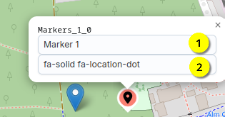
Course
A course is a line. You can draw these manually as a sequence of points or upload via GPX upload.
Give the track a name yourself . Since each
Track can also contain several lines, you can also name them. Click on
To do this, click on the line itself and enter a
Name for this line. You can then access this line in the reducer code by entering
You can access mapdata.track.road.
With you can change the start index for the track; this is displayed at the position on the map. As soon as you this display changes.
Info
The start index is normally the first point in a GPX file or the first
Point of the drawn line. This is required if you want to use the
Function nearestEdge (the polyline). This allows you to find the nearest point
on the line that is closest to a position. The system delivers
in addition to the coordinates, the distance to the start of the line; if the start index is not set to
0, the distance to the start index is calculated.
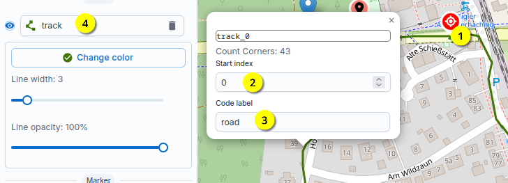
Participants
Participants are maintained separately in the system. The assignment to a competition takes place but about the competition.
You can therefore maintain a large list of participants in advance and then also as a participant in many competitions in advance. Only when you still establish a link via one (or more) devices, a link is created for the Participants also recorded data.
Note
A subscriber therefore does not have a fixed device ID, but the device is only authorised for one Competition is linked to the participant.
Optionally, you can also link a participant to a team; you can also
You can also enter a free text field for a value. Both values (teamid and attribute)
can be used in the reducer code at runtime.